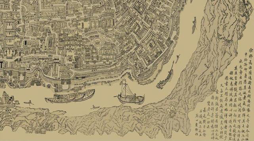
The Extended Version of Chongqing Map is one of the most detailed ancient maps of Chongqing. Created by Liu Ziru of the Qing Dynasty, it gives a detailed description of landforms, streets, and markets of ancient Chongqing with the Yuzhong Peninsula as center over a century ago. Unfortunately, the woodcut original has lost. But fortunately, the print replicate has survived and now is housed by China Three Gorges Museum of Chongqing as one of the precious map antiques about Chongqing's history and development. This has added more weight to Liu's status as a woodcut master.
Extended Version of Chongqing Map was treasured in Chongqing Three Gorges Museum.
In the ninth year of the reign of Tongzhi Emperor (1870), Liu Ziru, generational name Hua Zhang, was born in a farmer family at Xincun Village, Jinqiao Town, Wansheng District, Chongqing (former Shiwo Village, Qingshan, Qijiang County). In the ninth year of the reign of Guangxu Emperor (1883), 13-year-old Liu went to the town and was taken in by a monk who was then in charge of the Hongmiao temple located outside Linjiangmen along the Jialing River. Later, a seal engraver found Liu was smart and willing to learn and apprenticed him. After serving his apprenticeship, Liu returned to his hometown Qijiang County and opened a seal engraving shop. But due to poor business, he closed it soon and went to the town again at the age of 19. Since then, Liu had worked his way up and gotten a name for himself as a businessman, entrepreneur, philanthropist, and patriotic celebrity in the western regions, the whole country, and even the world during the 1900s-1940s.
The Extended Version of Chongqing Map is a freehand woodcut work that is 151.5 cm long and 85.5 cm wide.
Created from 1898-1902, it gives a detailed description of landforms, streets, and markets of ancient Chongqing with the Yuzhong Peninsula as center over a century ago. From east to west, it stretches from Chaotianmen to Futuguan, and from south to north, it starts from today's Nan'an District to the south of the Yangtze River and ends in Guanyin Bridge in Jiangbei District. Hand-painted or woodcut offers a survey of streets and rivers and a front view of ancient houses and structures of the day, making it a typical ancient map characterized by creating from multiple perspectives and by memory.
By continuing to browse our site you agree to our use of cookies, revised Privacy Policy and Terms of Use. You can change your cookie settings through your browser.
For any inquiries, please email service@ichongqing.info